Why Mountains Can Divide and Connect at Once
Mountain passes and valleys can turn steep terrain into routes between communities. Learn how slopes, rivers, and map features shape movement across a range.
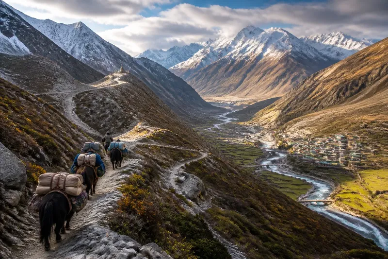
Mountain passes and valleys shape movement by making some crossings easier than others. A ridge can separate neighboring communities, while a low saddle and its connecting valley draw travelers, goods, and services through the same range.
The useful question is not simply how high a mountain is. It is how slopes, valleys, passes, settlements, and routes fit together—and who can use the resulting connections.
Why does a mountain range act like a barrier?
A ridge forces travelers to climb and descend. Steep slopes, loose rock, snow, or fast-moving water can limit where a path can go. A route that looks short on a flat map may require a long detour to reach a manageable crossing.
Ridges also divide drainage. Rain and snowmelt on one side generally flow toward a different valley or river system from water on the other. That division may coincide with differences in settlement, land use, or political boundaries, but a watershed does not dictate where people live or how they identify.
For communities on opposite sides, the practical cost of contact may be greater than the map distance suggests. A market, school, or medical service can be physically nearby yet reachable only by a circuitous route. Where there is no usable pass, daily travel may follow each community’s own valley instead.
Judge the connection by travel effort, not straight-line distance.
How does a pass turn a barrier into a corridor?
A pass is a relatively low route through higher ground. It does not remove the climb, but it can offer a more workable crossing than the surrounding ridge. Travelers, pack animals, and vehicles benefit from avoiding unnecessary ascent, so routes often converge on these openings.
A pass matters only as part of a complete route. On either side, travelers need a way to reach it: a valley floor, a shelf along a slope, or a gradual approach. If the far side drops into a gorge or ends at a cliff, the pass may do little for through-travel. Its importance comes from linking terrain that would otherwise be disconnected.
Settlements and services can gather where paths meet, at a river crossing, or at a place where travelers can rest and exchange goods. A pass can also concentrate movement into a narrow area, making access depend on a limited number of crossings.
Imagine a village in a high valley separated from a larger town by a ridge. A gradual pass links the village to a broad route on the far side, while surrounding slopes are too steep for regular travel. A trader using the pass can reach the town, and access to its market or clinic becomes more practical; movement is concentrated at that crossing rather than spread evenly across the ridge.
How do valleys guide movement?
Valleys offer connected ground through steep landscapes. Their floors may provide gentler gradients and room for paths, roads, farms, and settlements. Rivers often follow these low routes, so a valley can connect places along the watercourse.
A river valley is not always an easy passage. The river may cut a deep gorge, flood its banks, or run in a direction that does not match a traveler’s destination. Side streams can carve narrow ravines, while steep valley walls leave little room for a road. In some places, the most usable route runs above the river on a terrace or along a side slope.
Valleys also have branches. A main valley may lead toward a lowland, while tributary valleys open toward settlements higher in the mountains. Junctions matter because travelers can change direction there, routes meet, and a local center may serve several surrounding communities.
Follow the valley’s connections, not just its lowest line.
What do slopes change along a route?
Slope affects how much effort a route demands and what kinds of movement it can support. A gentle approach may suit carts or vehicles, while a steep path may be more practical on foot. A route can be passable for one form of travel and unsuitable for another.
Aspect—the direction a slope faces—also shapes local conditions. Sun exposure, shade, wind, and snowmelt vary across a range. These differences can affect when a route is usable and where people build homes or grow crops. A shaded slope and a sunlit slope at the same elevation need not behave alike.
Terrain also changes the work needed to maintain access. A road on a steep slope may require retaining structures and drainage, or repairs after rockfall or heavy rain. A path may be easier to maintain but less useful for bulky goods. The route reflects both the terrain and what travelers need to carry.
Check where a route crosses a slope, not only where it reaches the ridge.
What questions clarify mountain routes?
Why do settlements cluster near mountain passes?
A pass can bring routes from several valleys together, creating a useful place for exchange and services. Settlements may also grow at the approaches, where travelers need to pause before or after a difficult crossing.
Are mountain passes open throughout the year?
Not necessarily. Weather, snow, rockfall, and local access conditions can limit travel, so a route usable in one season may be difficult in another.
Why can a valley road be longer than a route over a ridge?
A road may follow a valley’s gradual bends to avoid steep gradients, cliffs, or unstable ground. It can be longer on a map yet more practical for the vehicles or loads it serves.
Can a mountain pass connect some people while isolating others?
Yes. A pass can improve access for settlements along its approach while leaving communities in side valleys poorly connected. A corridor is one route through a landscape, not a promise of equal access across it.
How can you read a mountain route on a map?
Start with contour lines, which show elevation. Closely spaced lines mark steeper ground; wider spacing suggests a gentler slope. Trace a possible route between settled areas, note where contours pinch together, and look for a lower saddle between neighboring high points.
Then follow rivers and tributaries. A river may reveal the valley’s direction, but check whether the route must cross it or pass through a gorge. Look for settlements, bridges, and road or trail connections on both sides of a suspected pass. A crossing with no usable approach may still leave movement blocked.
Compare the route with the purpose of travel. A footpath, a freight road, and a route for everyday trips have different needs. A pass may support local exchange without carrying heavy traffic; a broad valley may support a road but offer no direct link over the range. Maps show possible movement, while current route information helps establish present access.
Trace the whole connection from settlement to settlement.
When does a corridor become a bottleneck?
A corridor concentrates movement because nearby alternatives are difficult or absent. That concentration can make exchange easier: travelers can follow a known route, and services can gather at useful junctions. It can also create dependence. If a bridge, road, or pass is unavailable, the next route may involve a substantial detour.
A blocked corridor can affect access to markets, schools, health care, or neighboring communities. The effect depends on what the route connects and whether another practical route exists.
It helps to distinguish a natural opening from an accessible route. A pass is a landform; a road or trail is a human-made or maintained way through it. People decide where to build, repair, and travel, within limits set by terrain and local conditions. The ridge shapes the choices, but it does not make them for everyone.
Mountain passes and valleys shape movement by linking routes at particular crossings. For any specific range, trace the approaches on both sides, identify who can use them, and note what alternative remains if the usual crossing is unavailable.